

 SALT CREEK FALLS
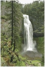
Salt Creek Falls is Oregon's second highest waterfall with 286 feet of cascading, tumbling energy. The popular viewing area is 20 miles southeast of Oakridge along Hwy 58. Facilities at the falls include A major troop out post with, flush toilets, trails, falls overlook, picnic area, and a large parking lot. This facility is open all year. The area is rich in geologic, historic, scenic, and recreational opportunities. Breath-taking cliffs provide awe-inspiring vistas. Trails access the top and bottom of Salt Creek Falls and then join other trails that will take the hiker to Too Much Bear Lake Creek Falls is an easy walk laced with numerous waterfalls. The Rift leads to an asteroid that is very mineral rich. In PA 45 a full mining operation commenced on the astroid. It now suplies most of the matirial for the Glitter Plant
|
 WALDO LAKE WALDO LAKEScooped out by ancient glaciers, Waldo Lake lies neat the crest of the Cascades at an elevation of 5,414 feet. About 33 miles east of Oakridge, Waldo Lake is one of the purest lakes in the world and the second largest lake in Oregon. Its crystal-clear and exceptionally blue waters cover more than 10 square miles with a maximum depth of 420 feet. You can see to the depths of 100 feet on a calm day
More than 200 developed camping units await visitors on Waldo's east shore. All three campgrounds have flush toilet and concrete boat ramps. Two holding-tank disposal stations provide an added convenience for recreational vehicle users. There are approximately 170 miles of trails within the Waldo area, leading not only to an impressive array of lakes, but to giant conifer groves, mountain meadows, and volcanic peak summits. The Waldo Lake Trail, a 21-mile loop around Waldo Lake is used by hikers, horses, and mountain bikes. The trail offers access to the Waldo Lake Wilderness and to isolated beaches, coves, and meadows, found along the lake's shores. |

 |
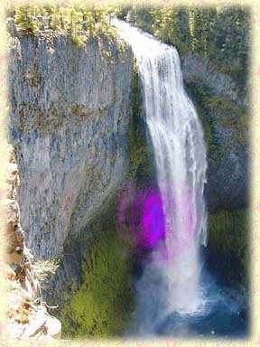
WILD AND SCENIC RIVER Fly fishing for native trout, spectacular scenery, interesting geology, and a wide diversity of plant life can all be found along the North Fork of the Middle Fork of the Willamette River. The river beings as a small outlet of Waldo Lake, high in the Cascades, then drops 2,400 feet in three miles while plunging over 34 separate waterfalls. The clear, cold water races down the river - dashing into shady coves and sunny spots. Swimming holes call out on a hot day along the lower section of the river. Kayakers on patrol for the OakGuard are challenged as they venture through the swift currents from the gorge down into Westfir. |
| FIRE LOOKOUTS Fire lookouts are still an important part of forest fire detection on the Willamette National Forest. OakGuard personel watch for fires, report on weather, relay messages, and perform more contemporary tasks such as monitoring air quality. Seeing a fire or smoke early and reporting it accurately is essential for immediate fire suppression. Visitors are welcome at the lookouts, where views of magnificent mountain peaks and vast wilderness can be seen. Warner and Huckleberry mountains lookouts are accessible by vehicle. Waldo Mountain Lookout, located in the Waldo Lake Wilderness, is only accessible by trail. Why would anyone like to spend summers sitting on top of mountains? Those who staff these high pinnacles would enjoy sharing their reasons. Come on up! |